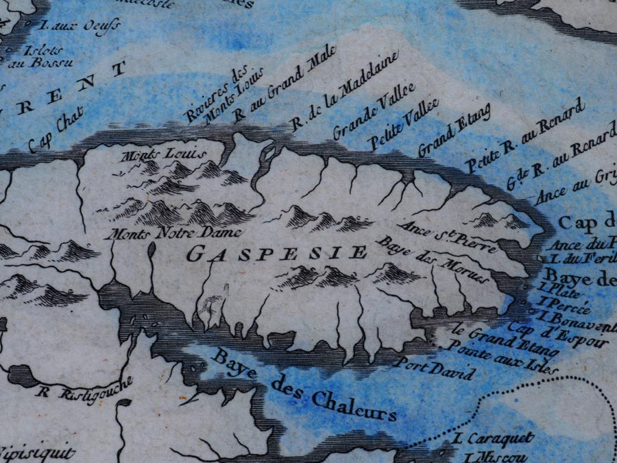
Our ideal recipe for a summer or fall Canadian road trip is to load our small camper van and head for the Gaspé, that eastern peninsula of Quebec just south of the mighty St. Lawrence River and north of New Brunswick. It was a little less than a thousand kilometres to do the circle, following Route 132, immersing our senses in the place where land meets sea.
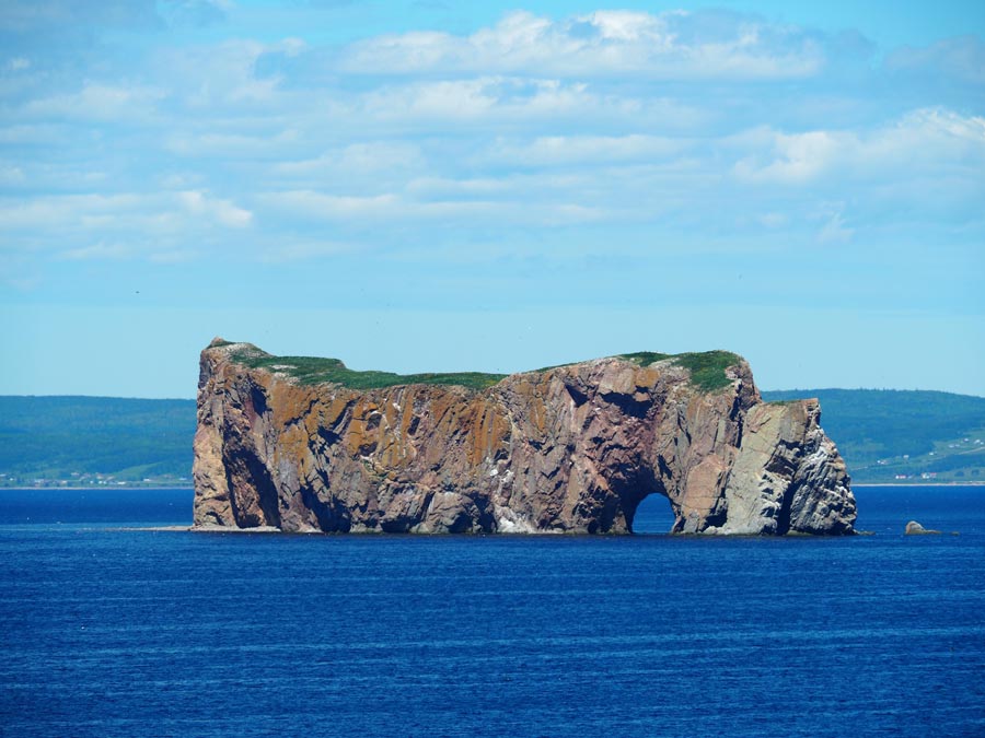
As we approached the far eastern regions of the Gaspé, the landscape shifted from the gentle roll of farmlands and small fishing villages to the (at times) rollercoaster-like hills of The Haute-Gaspésie, before spilling into the breathtaking Land’s End region, best known for landmarks Forillon National Park and Percé Rock (above).
RELATED: On the Road Again – Quebec’s Gaspé Peninsula, Part 1: The North Coast
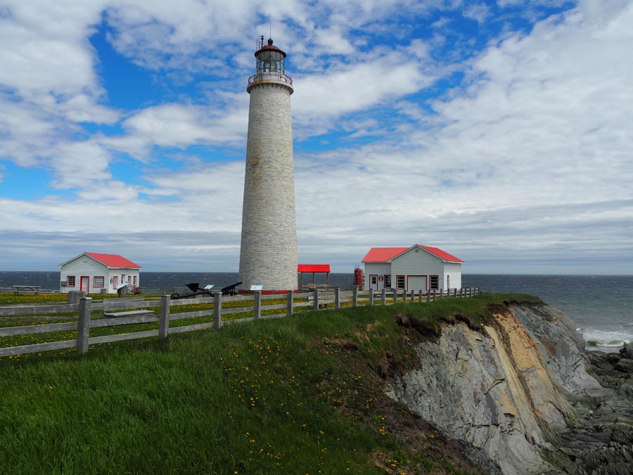
The St. Lawrence River can be tempestuous when it comes to weather and challenging to navigate, making the dozens of lighthouses along the route crucial sentinels of the sea. There’s an official Lighthouse Trail with nine Gaspé sites open to the public. We stopped at Cap-des-Rosiers Lightstation, just before the north entrance to Forillon National Park. This was the first lightstation in the Gaspé – and the tallest in Canada – now a National Historic Site at the edge of the village named by explorer Samuel de Champlain. Built in the mid-1800s, the burners to power the beacon were first fuelled by whale oil, then petrol and now electricity. However, the original polished glass lens from France is still in use.
Land’s End is the treasure trove at the midpoint of a beautiful driving route. The Parks Canada site – Forillon National Park – is known for hiking trails, wildlife, scenic views, coastal sea kayaking and historic sites. We indulged a little bit of everything.
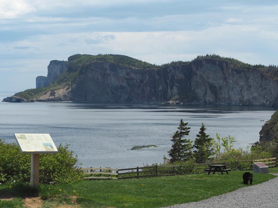
Forillon itself is a smaller peninsula, with the north shore jutting out into the Gulf of St. Lawrence and the southern shoreline facing the more moderate Gaspé Bay. We began by looking for “dramatic” and found it quickly where the northern road ends at Cap-Bon-Ami. The coastline of 375-million-year-old cliffs marks the terminus of the Appalachian Mountain chain as it dips into the salty waters. It’s a haven for seabirds that swoop and swirl above. We watched for an hour – from a safe distance – as a mama bear and her two cubs nibbled the grasses and flowers along the walkway by the water’s edge.
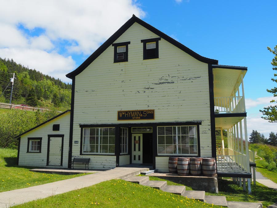
Touches of history and civilization have been preserved at park sites like Hyman & Sons General Store, a restored shop that served the area’s golden era of cod fishing. Shelves are stacked with the necessities of the day: buttons, rope, fabric bolts, boots and canned goods. It was cod that first brought settlers to the Gaspé and a display leads visitors through the seasonal work faced by the cod fishing families.
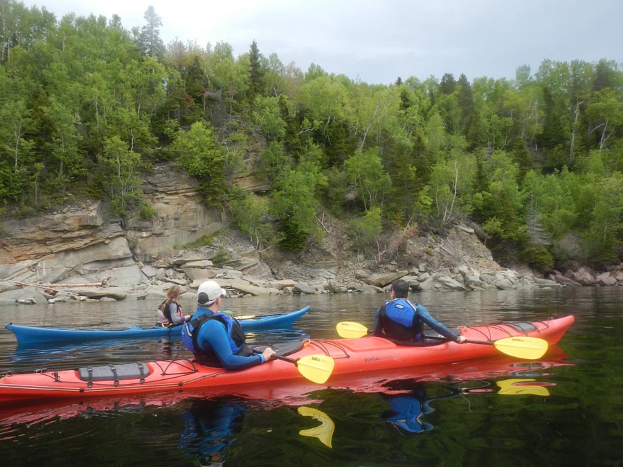
The next day was an early start with Cap Aventure, a sea kayaking outfitter who led our small group of dual kayaks along the rocky shoreline of Gaspé Bay, in search of harbour sea colonies. Roxane, our bilingual guide, was safety conscious as well as environmentally mindful, making sure we stayed a respectable distance from the wildlife. We were treated to a chorus of seals barking, the sight of them playing in the water and lazing on the warm slabs of shoreline rock.
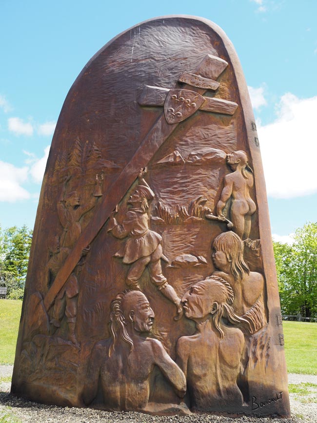
Leaving Forillon was . . . bittersweet. We could have stayed for weeks, exploring hiking trails like La Chute and Les Graves, which ends at Cap- Gaspé lighthouse. But we pushed on to the wonderful Musée de la Gaspésie in the town of Gaspé. This excellent museum showcases the maritime history of the Gaspé, through a 3D film experience, interactive exhibits, detailed models and tributes to historical players. Jacques Cartier was the first European to sail into Gaspé Bay in 1534, where he erected a wooden cross to take possession of the territory for the King of France. This signalled the founding of New France, the French empire in North America.
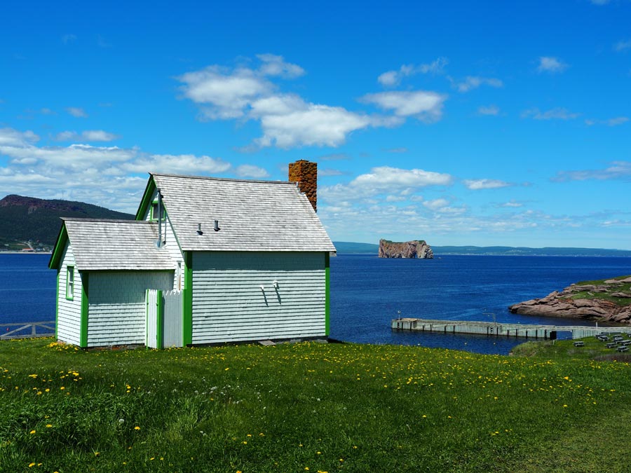
There was one more rollercoaster-like hill that dipped into the village of Percé, a village renowned for its breathtaking chunk of 400-million-year-old limestone (rising from the sea and pierced with a large opening), its lobster catch, the nearby L’Île-Bonaventure and, perhaps not as well known, the seedling ground for the FLQ. Compact and easily walkable, Percé’s waterfront main street is a mix of artisan shops, patios, bistros and seafood eateries.
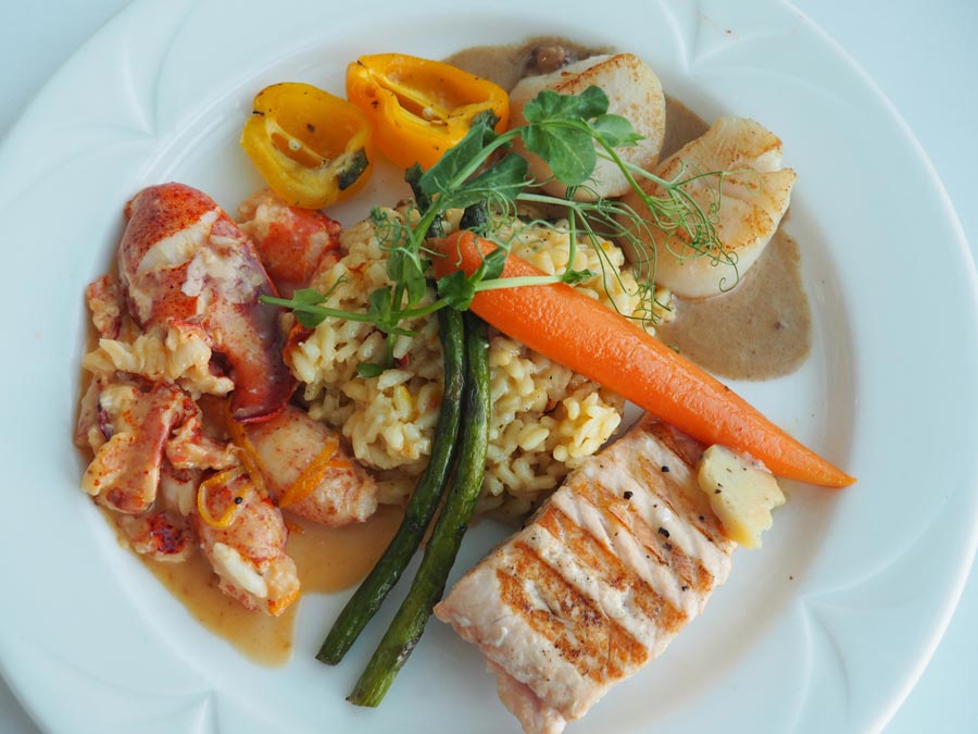
We had the best meal of our trip at La Maison du Pêcheur, where it was impossible to say no to fresh-caught lobster, enormous sea scallops, salmon and Arctic char.
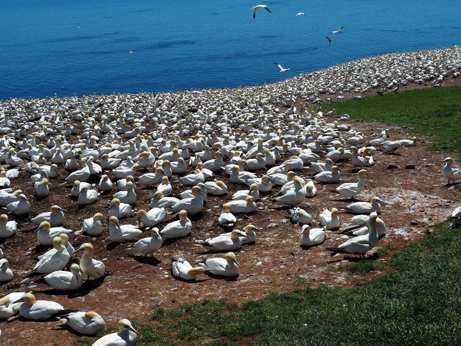
No visit to Percé is complete without a boat tour around the famous rock and a stop at L’Île-Bonaventure to hike the island’s trails and see the bird colony of 48,000 pairs of Northern gannets who come to nest on the cliffedge. On the boat ride around the island, we spotted minke whales and seals, and hundreds of seabirds nesting in the vertical rock. Before the First World War, this area was booming with the fishing industry. Fishing went into decline after the war and the entrepreneurial fishermen added benches to their boats and spawned a tourism industry by taking visitors out onto the water. A century later the boats may have changed, but tourism still has a stronghold and the boats are still getting them out for the priceless view from the water.
IF YOU GO
www.parkscanada.gc.ca/forillon
RELATED: On the Road Again – Quebec’s Gaspé Peninsula, Part 3: Chaleur Bay
Who’s writing
Two people, one dog and a 2006 Roadtrek camper van. We’ve immersed ourselves in the RV road trip lifestyle, drawn by the flexibility and independence. There’s more on our website devoted to our travels and writing: www.travelswithrigby.com with info on RV travel, how to buy an RV, dog-friendly travel, food and music destinations.
'%3E %3Cg id='Group'%3E %3Cpath id='Vector_2' d='M12.4876 13.8996V13.4213H0.743091V15.2149H9.18805L9.22196 15.2685C9.19653 15.2272 3.24373 25.2836 0.74521 29.5469C0.420975 30.1015 0.0797856 30.7158 0.0797856 30.7158C0.0713089 30.7323 0.0585938 30.755 0.0585938 30.755H12.1401V28.9614H3.67181L3.6379 28.9078C3.37512 29.1222 12.4876 13.8996 12.4876 13.8996ZM36.1229 22.115C36.1229 26.4896 33.7537 29.18 31.1683 29.18C28.5829 29.18 26.1861 26.4896 26.1861 22.115C26.1861 17.7403 28.5553 15.0231 31.1683 15.0231C33.7812 15.0231 36.1229 17.7403 36.1229 22.115ZM22.0155 22.115C22.0155 26.4896 19.6462 29.18 17.0587 29.18C14.4712 29.18 12.0765 26.4896 12.0765 22.115C12.0765 17.7403 14.4458 15.0231 17.0587 15.0231C19.6717 15.0231 22.0155 17.7403 22.0155 22.115ZM38.223 22.0613C38.223 16.7095 35.0443 13.1492 31.1661 13.1492C27.288 13.1492 24.3402 16.4312 24.0987 21.4326C23.8592 16.4333 20.7842 13.1492 17.0587 13.1492C13.3332 13.1492 9.97427 16.7074 9.97427 22.0613C9.97427 27.4153 13.1785 31.0003 17.0587 31.0003C20.9389 31.0003 23.8592 27.7183 24.0987 22.6922C24.3402 27.7162 27.4406 31.0003 31.1661 31.0003C34.8917 31.0003 38.223 27.4421 38.223 22.0613ZM51.3747 30.755H53.5257L52.3178 13.4213H50.1668L45.797 27.3328L41.4273 13.4213H39.2763L38.0662 30.755H40.2172L41.0352 19.0247L44.7205 30.755H46.8714L50.5567 19.0247L51.3747 30.755ZM53.9453 30.755H62.3797V28.9614H56.0963V22.9293H60.964V21.1357H56.0963V15.2128H61.8859V13.4192H53.9453V30.7529V30.755ZM69.3624 18.2021C69.3624 20.1029 68.1333 21.1625 66.7367 21.1625H64.893V15.2128H66.7092C68.1333 15.2128 69.3624 16.3261 69.3624 18.2021ZM71.5134 18.1753C71.5134 15.2128 69.3348 13.4213 67.0164 13.4213H62.7993V30.755H64.893V22.9313H66.7092L71.5112 30.755H73.997L68.8601 22.4695C70.369 21.8717 71.5134 20.3502 71.5134 18.1773' fill='%23231F20'/%3E %3C/g%3E %3C/g%3E %3C/g%3E %3Cg id='Group_2'%3E %3Cpath id='Vector_3' d='M9.67285 8.56629V3.50513H12.6249V4.11535H10.5947V5.71719H12.2943V6.32742H10.5947V7.954H12.9046V8.56423H9.67285V8.56629Z' fill='%23231F20'/%3E %3Cpath id='Vector_4' d='M17.6819 8.6137H17.2581L15.1855 3.50513H16.1392L17.0822 5.86975C17.2178 6.20991 17.362 6.63872 17.4976 7.05103H17.5188C17.6544 6.64696 17.7879 6.2264 17.9341 5.86975L18.8666 3.50513H19.7482L17.6862 8.6137H17.6819Z' fill='%23231F20'/%3E %3Cpath id='Vector_5' d='M22.4072 8.56629V3.50513H25.3593V4.11535H23.3291V5.71719H25.0287V6.32742H23.3291V7.954H25.639V8.56423H22.4072V8.56629Z' fill='%23231F20'/%3E %3Cpath id='Vector_6' d='M31.6164 8.56629L29.9698 6.32123H29.2959V8.56629H28.374V3.50513H30.0948C30.9552 3.50513 31.805 4.01227 31.805 4.90906C31.805 5.54402 31.3896 5.97283 30.8725 6.16249L32.6654 8.56629H31.6185H31.6164ZM29.9592 4.10711H29.2959V5.71719H29.9592C30.436 5.71719 30.8704 5.43888 30.8704 4.90906C30.8704 4.37923 30.436 4.10711 29.9592 4.10711Z' fill='%23231F20'/%3E %3Cpath id='Vector_7' d='M37.5849 6.27382V8.56629H36.6737V6.28206L34.6943 3.50513H35.667L36.6503 4.90081C36.8156 5.13789 37.0021 5.38528 37.1378 5.59968H37.159C37.3031 5.39353 37.5001 5.11522 37.657 4.90081L38.6403 3.50513H39.5621L37.5828 6.27382H37.5849Z' fill='%23231F20'/%3E %3Cpath id='Vector_8' d='M44.3084 4.11535V8.56629H43.376V4.11535H41.7188V3.50513H45.9656V4.11535H44.3084Z' fill='%23231F20'/%3E %3Cpath id='Vector_9' d='M52.0484 8.56629V6.32948H49.499V8.56629H48.5771V3.50513H49.499V5.71926H52.0484V3.50513H52.9808V8.56629H52.0484Z' fill='%23231F20'/%3E %3Cpath id='Vector_10' d='M56.2129 8.56629V3.50513H57.1453V8.56629H56.2129Z' fill='%23231F20'/%3E %3Cpath id='Vector_11' d='M64.7402 8.64463L62.4091 6.17693C62.0467 5.79553 61.6208 5.31106 61.2796 4.91524L61.2584 4.92349C61.2796 5.3523 61.2902 5.7811 61.2902 6.13776V8.56629H60.3789V3.50513H61.0316L63.1868 5.82233C63.4878 6.14806 63.9222 6.63872 64.2337 7.00362L64.2549 6.99537C64.2337 6.62223 64.2231 6.17899 64.2231 5.83677V3.50513H65.1344V8.64669H64.7402V8.64463Z' fill='%23231F20'/%3E %3Cpath id='Vector_12' d='M70.9048 8.64416C69.4235 8.64416 68.0566 7.69172 68.0566 6.03421C68.0566 4.37671 69.4659 3.41602 70.8752 3.41602C71.5999 3.41602 72.17 3.57476 72.5324 3.78091L72.3883 4.42412C72.0471 4.21797 71.5491 4.05098 71.0002 4.05098C69.9639 4.05098 68.9912 4.77253 68.9912 6.04246C68.9912 7.31239 69.9448 8.01745 70.9599 8.01745C71.405 8.01745 71.7567 7.93911 71.975 7.7948V6.61352H70.8349V6.03421H72.8354V8.12877C72.3586 8.47718 71.7271 8.64416 70.9091 8.64416H70.9048Z' fill='%23231F20'/%3E %3C/g%3E %3Cpath id='Vector_13' d='M0.0839844 1.00212L73.997 1' stroke='%23231F20' stroke-width='1.25' stroke-miterlimit='10'/%3E %3Cpath id='Vector_14' d='M0.0839844 10.9116H73.997' stroke='%23231F20' stroke-width='1.25' stroke-miterlimit='10'/%3E %3Cpath id='Vector_15' d='M4.91016 4.15649L3.55812 4.13794L5.18777 5.7068L0 5.6532V6.5974L5.20049 6.651L3.61321 8.18068L4.96526 8.19718L7.0018 6.20157L4.91016 4.15649Z' fill='%23D71920'/%3E %3C/g%3E %3C/svg%3E)
